|
|
|||||||||||
|
|
|
|
|||||||||
|
|
|||||||||||
|
|
|
|
|||||||||
|
Contents Inroduction |
Click on required item to go to that part of the document |
||||||||||
|
Appendices Habitat Survey |
This proposal presents a simple alternative to housing as a means of re-instating the derelict mill site adjacent to Polton Village in the North Esk Valley thus protecting this spectacular part of Midlothian’s valuable countryside for future generations.
Points to Support This Proposal
Environmental Issues
Technical Issues
Community Issues
The points raised above are amplified individually in the following pages
The Proposal
Phase 1 Site Clearance
Phase 2 Ongoing Management
Phase 3 Future Enhancements
Cost To achieve Phase 1 above- Within £100K
Funding Possible Sources Identified
The points raised above are amplified individually in the following pages
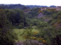
The North Esk Valley – Nature’s Corridor
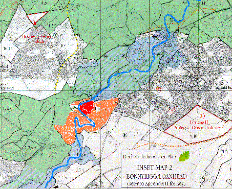
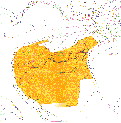
Springfield Mill is located in the Valley of the River North Esk to the south of Polton village, as shown in the map (Figure 1) below. It lies down river from Roslin Glen Scottish Wildlife Trust Nature Reserve and the proposed Roslin Glen Country Park. The site is overlooked by Hewan Bank SSSI and a footpath that will form part of the North Esk Walkway. The area of the river valley in which the site lies, between the road bridge at Roslin Glen and Springfield Bridge, is currently one of the "wildest" stretches where bar Hawthornden and Roslin Castles there is no human habitation.
As more and more development takes place in the surrounding areas of Midlothian, protection of this spectacular natural feature becomes more and more important. Once taken, it is lost forever to future generations.
Key to Designated Areas
1 = Protection of the countryside
4 = AGLV
6 = Nationally important conservation site
Need to protect the green belt
The above map shows that the site is entirely surrounded by Green Belt land. It should be part of the green belt and its protection therefore a priority.
A nationally important conservation area
The site is adjacent to the Mavisbank Conservation Area and is overlooked by a nationally important conservation area.
An area of great landscape value
The site itself is within an Area Of Great Landscape Value requiring Protection Of The Countryside.
Site of Special Scientific Interest
Hewan Bank, which lies adjacent to the site on the other side of the river, was declared a sit of special scientific interest in 1988. Hewan Bank (SSSI) lies in an oxbow. This narrow peninsula of unconsolidated glacial sediments will continue to be eroded by the North Esk until the river cuts a course right through it. Erection of a flood barrier is likely to increase the force of the water hitting the bottom of Hewan Bank at times of heavy rainfall thus accelerating erosion and increasing frequency of landslides. The mature trees on Hewan Bank were removed in the mid-eighties but there has already been significant regeneration. Unless the trees are removed on a regular basis there will be a danger of large land slips containing woody material which might dam the river to such a depth that flood protection would be rendered useless. Erection of a flood barrier, which would certainly be necessary to protect any houses built on the site, or any other interference with the bank, would be contrary to section 13bof the SSSI damaging operations list (see Appendices), which is forbidden by law.
Disturbance of existing wildlife
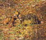
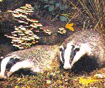
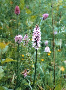
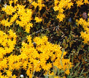
The site is already of very considerable value to wildlife. The river and banks on either side to a distance of 30m have been recognised as a Scottish Wildlife Trust Listed Wildlife Site and the Planning Secretary of SWT has written to Strategic Services to suggest the possibility of the site becoming a "conservation site". The results of an initial habitat survey appear in the appendices. Approximately 4ha of the site is already wooded and this area makes a significant contribution to the Roslin Glen to Bilston Glen semi-natural woodland area. There has been over the last 30 years or so a great deal of natural regeneration of native tree species that has provided areas of birch, elm and willow scrub. These are wonderful for nesting songbirds and have a rich insect fauna. Both this semi-mature and the mature woodland are inhabited by large mammals such as roe deer, badgers (there is a known set on the boundary of the site and probably others within) and foxes. Rabbits, small rodents, shrews and mustelids also abound. This year small pools that remain at the site of the fishpond were full of tadpoles but these unfortunately perished when the water evaporated. Frogs, toads and smooth newts have all been found at Springfield Mill. The derelict part of the site provides both grassland and ruderal habitats. Here are found hundreds of spotted orchids, mullein, toadflax and a wonderful diversity of other plants which provide fodder for many insects among them butterflies such as the red admiral, peacock, small tortoiseshell and rare visitors such as the convolvulus hawk moth and the purple hair streak butterfly. The river walls provide a vantage for the resident kingfishers and the river itself is home to dippers, pied and grey wagtails, brown trout, eels and the plethora of invertebrates which inhabit any such healthy, fast flowing watercourse. Above the site wheel sand martins from Hewan Bank and sparrow hawks and at night these are replaced by a multitude of bats some from the roost in the riverside building while resident tawny owls hunt over the site.
Interference with natural flood plain
As well as protecting Hewan Bank, the site is the natural flood plain for the community of Polton Village. If flood defences are constructed to protect houses built on the site then Polton Village may be at increased risk in the event of a sand slide at Hewan Bank.
Inadequate local roads
Vehicular access to the site is from Bonnyrigg via Polton Bank or from Loanhead via Polton Road. The former is on a steep gradient and has an extremely tight double bend part way down. The roadway is narrow. Two heavy vehicles would be unable to pass though there is a thin pavement to the side of the uphill lane. Polton Road has an even steeper gradient and is extremely twisting and barely wide enough to allow the passing of two cars for most of its length. There is no footpath. Both roads are bounded on both sides by high walls. Two recent council studies have revealed that in addition to many horse riders from several stables in the vicinity, cyclists and pedestrians some 600 vehicles per day currently use these roads mainly to travel between Bonnyrigg and Loanhead. This level of traffic usage represents a doubling since a survey carried out in 1993 and is probably a contributory factor to the poor state of Springfield Bridge, which crosses the North Esk to join the two roads.
The recent increases in housing around Bonnyrigg and the expansion of the Straiton and Pentland retail parks, in particular the impending opening of Ikea, will considerably increase the traffic on these roads.
Twenty-five extra houses will mean at least 50 extra cars and some 100 additional journeys per day. Increased traffic at a time when there were 300 vehicle journeys per day was given as the reason for constraining the houses to 25. Now that there are already 600 journeys per day, no further houses can possibly be considered.
Impact on Polton Village
A development of 25 houses would more than double the size of Polton Village as well as extend it across the present boundary road.
The North Esk Way
Plans are underway to establish a walkway along the North Esk Valley from Musselburgh to Penicuik under the aegis of the Edinburgh Green Belt Trust and with support from Lasswade District Civic Society, Loanhead Environment and Conservation Group and Roslin Heritage Society. The walkway will use the existing path which looks immediately down on the site. A relatively large group of houses in this location will destroy much of the rural aspect of the way at this spectacular point.
A letter emphasising the above has recently been sent to the Council by the Pathways project team of Lasswade District Civic Society and this in included in the appendices.
Extensive local opposition
At the time of the last meeting of the Midlothian Council Strategic Services Committee, a total of 99 letters against the development had been received. These have been from private individuals, both local and from further afield, as well as a number of recognised environmental organisations.
Support from recognised local and environmental bodies
Lasswade District Civic Society, Loanhead Environment and Conservation Group and Scottish Wildlife Trust have all expressed opposition to the threatened housing development. In addition SMAG has consulted with Scottish Natural Heritage, Edinburgh Green Belt Trust and the Royal Society for Protection of Birds.
Housing is not needed
It has been stated publicly by the Council that Midlothian has already identified sites for the additional housing needed in this area. These 25 houses are not required to meet local housing needs but rather to provide profit for a developer.
The Proposal - detail
Phase 1 Site Clearance
Measures to minimise effects on existing wildlife during clearance.
Demolition of remaining buildings and very limited decontamination work.
Crushing of rubble and its formation into small mounds with the aim to keep the site as low lying as possible and to form a flood channel.
Possible addition of low grade top soil and some planting of native trees/ sowing of native grassland and wildflower seed mixes on mounds.
Leave parts of current hard standing as a path along the river and through the site.
Phase 2 Ongoing Management
Writing and implementing a management plan for the site which will involve money from grant sources and the labour of local volunteers. Expertise within the group could be drawn on to prepare this plan.
Involvement of local community groups and schools.
Local business sponsorship.
Phase 3 Future Enhancements
Digging out and puddling of small pools in the marshy area which used to be the fishpond to encourage amphibians to breed.
Placing bat boxes in existing woodland.
Further planting of local species and discouragement of undesirable species invasion.
Cost Estimates
We have obtained indicative estimates from two demolition companies for Phase 1 clearance operations and one of these is included in the appendices. Both are at £85 thousand. Allowing for possible limited decontamination in the only area near the river, we believe that the total cost of Phase 1 will be within £100 thousand. Indications from several sources are that we would not have to pay for the spreading of low-grade (best for natural vegetation) topsoil as many firms are looking for places to dump this.
Funding
At such an early stage it has of course not been appropriate to attempt to secure funding but potential sources have been identified. The Council will no doubt realise that its approval of SMAG’s proposals is vital to our quest for financial backing. Possible funding sources are:-
Land Fill Tax Credits from operators registered with Customs and excise in and around the Lothians. Two particular targets would be Midlothian Council and Tarmac’s Millfields Environmental who run the tip at Mellville Sandpit.
History
The first paper mill at Springfield began operation in 1742. Local knowledge indicates that the original Mill lade and turbine system is still present on the site though now infilled. The Mill itself covered only some 2ha of the site the remaining 4 ha being the gardens and policies of Glenesk House. Although the house is now gone the mature woodlands established in the late 1800s are still present and harbour large specimen trees among them what is reputed to be the largest Araucania (Monkey Puzzle) in Midlothian. The outline of the old fishpond is still clearly visible though it is now reduced to a sedge and willow marsh. All of the preceding features are shown in an ordnance survey map of the site as it was in 1894.
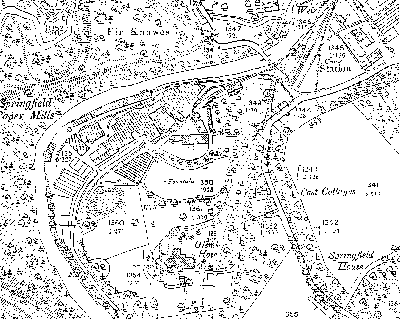
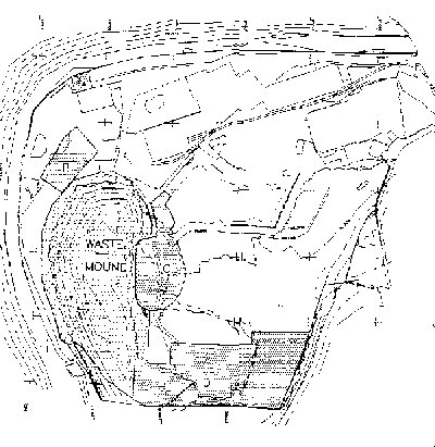
During the early part of this century Polton Village was a thriving industrial community with two working paper mills serviced by a railway. In the late 1960s Springfield Mill ceased production and at the time of regionalisation in 1975 the land shown in Fig.3 became the property of Lothian Region and Midlothian District Council. Prior to 1979 the main site offices and two warehouses were used by the District’s Technical Services and Housing Department and the Region’s Highway’s Department used part of the area for an open storage yard. The rest of the buildings and yards on the mill site (some of which were in private ownership) were occupied by a variety of local businesses.
Flooding on the site of Springfield Mill had long been a problem. The site lies on a flood plain under the steep, unstable, 50m Hewan Bank. On 9th December 1979 after prolonged rainfall a huge landslide occurred completely blocking the North Esk with mud, rocks and woody material to a depth of 8 metres. The toe of the slide swept across the river into the Mill complex demolishing part of the building used by Midlothian Council. Water then ran through the site flooding it to a depth of a metre.
At this time Hewan Bank was covered in mature trees. In 1980 and again in 1985-86 at great expense a Manpower Services Commission squad cleared these to reduce the danger of their damming the river in future slips. In recent years the bank has continued to slip and the site flooded again in the early 1990s. In December 1992 Midlothian District Council approved a planning application by the current owner of the part of the mill site not in public ownership for flood protection works. The application lapsed one year later.
By 1984 the District and regional Councils had begun to address the problem of the disused paper mills at Polton commissioning surveys of the sites. The Bonnyrigg and Loanhead Issues and Options document of June 1985 earmarks Springfield Mill for 20 houses.
In April 1987 in recognition of the unsuitability of the site for continued industrial use the Regional Council produced its Feasibility Study for Rehabilitation of Springfield and Polton Mills. This report suggested that Springfield Mill be rehabilitated mainly for open space usage but with a small housing element (20 units) to generate funding for the project. This represented a relaxation of the policy on the North Esk Valley at the time which was and still is to resist building in the valley which is recognised as an Area Of Great Landscape Value. In addition since 1975 it had been Midlothian Council’s policy to maintain a "green corridor" between Bonnyrigg and Loanhead. The report did include cost estimates and a map for a solution which did not involve housing if another funding source had to be found.
A Report to Midlothian District Council’s Planning committee dated 20th April 1988 summarises the approval of an application by the Scottish Development Agency for the demolition of mill buildings, rehabilitation, landscaping, formation of footpaths, and outline planning permission for 25 houses at Springfield and Polton Mills. The conditions for the allowance of the building of houses were many and recognised the presence of mature trees over much of the Springfield Mill site. It was also stressed in this report that the existing vehicular access to the site was "suitable for accommodating a very limited volume of additional traffic". (Traffic on these roads has now at least doubled!) The permission lapsed five years later.
In December 1988 Lothian Region served the owner of the part of the site not in their ownership with a compulsory purchase order as their planned rehabilitation of Springfield Mill was dependant on the acquisition of the whole site. The order was challenged by several interested parties and on 27th February 1990 the Secretary of State refused the Council the power of compulsory purchase. The Secretary of State’s Report at this time points out that a Mr. Dodd on behalf of McNeil Properties Ltd. stated that "his company was interested and capable of carrying out the whole project with no contribution from SDA, including acceptance of the terms of the Section 50 agreement and an offer of alternative premises for tenants" and "his company could start at once and complete the rehabilitation within 9 months and the whole project by the summer of 1992". In March 1990 Robert and James McNeil bought the part of the site not in Council ownership presumably with the intention of acquiring the rest of the Mill site in due course. During later exchanges with the Council it is rumoured that they expressed a desire to build many more houses on the site figures as high as 100 have been mentioned.
Since 1990 at least in part due to flooding problems and the declining state of the mill buildings the site has been completely vacated and derelict buildings demolished. Only two buildings now remain- a large warehouse and a smaller building on the riverside which accommodates an electricity substation. Both of these buildings are in a poor state of repair.
On 15th September 1998 Midlothian Council agreed to sell 5.71ha of land to James MacNeill Properties Ltd. (No company of this name appears to be registered in UK). The Director of Regulatory Services has advised that the terms of this sale would require rehabilitation of the whole site.
The Springfield Mill Action Group became aware of the potential development threat at the Mill on March 21st 1999 and have, since then, campaigned for the removal of the site from the Register of Housing Land Supply in the new local plan. Strategic Services have to date received 99 letters in support of this action and SMAG’s voice has been joined by those of Lasswade Civic Society, the Scottish Wildlife Trust, Loanhead Environment and Conservation Group and Bonnyrigg Community Council.
|
|
|
|
The site is already of very considerable value to wildlife. The river and banks on either side to a distance of 30m have been recognised as a Scottish Wildlife Trust Listed Wildlife Site and the Planning Secretary of SWT has written to Strategic Services to suggest the possibility of the site becoming a "conservation site". Fig. 4 gives the results of an initial habitat survey. Approximately 4ha of the site is already wooded and this area makes a significant contribution to the Roslin Glen to Bilston Glen semi-natural woodland area. There has been over the last 30 years or so a great deal of natural regeneration of native tree species which has provided areas of birch, hazel and willow scrub. These are wonderful for nesting songbirds and have a rich insect fauna. Both this semi-mature and the mature woodland are inhabited by large mammals such as roe deer, badgers (there is a known set on the boundary of the site and probably others within) and foxes. Rabbits, small rodents, shrews and mustelids also abound. This year small pools which remain at the site of the fishpond were full of tadpoles but these unfortunately perished when the water evaporated. Frogs, toads and smooth newts have all been found at Springfield Mill. The derelict part of the site provides both grassland and ruderal habitats. Here are found hundreds of spotted orchids, mullein, toadflax and a wonderful diversity of other plants which provide fodder for many insects among them butterflies such as the red admiral, peacock, small tortoiseshell and rare visitors such as the convolvulus hawk moth and the purple hair streak butterfly. The river walls provide a vantage for the resident kingfishers and the river itself is home to dippers, pied and grey wagtails, brown trout, eels and the plethora of invertebrates which inhabit any such healthy, fast flowing watercourse. Above the site wheel sand martins from Hewan Bank and sparrow hawks and at night these are replaced by a multitude of bats some from the roost in the riverside building while resident tawny owls hunt over the site.
Local Geology and Nature of Materials on Site
.A 1992 study LEEL funded study identified that the site comprises in descending order:
A contamination survey showed the site to be polluted in five discreet areas (Fig. 5) with many different contaminants which reflect the past industrial uses of the site. Both the District Council and SEPA have confirmed that currently there does not seem to be any significant pollution to the North Esk from the site or any immediate risk to health or the environment. In fact according to SEPA records the site lies adjacent to the cleanest stretch of the North Esk. Samples taken upstream of the site at Roslin Bridge indicate a water quality of Class B (fair), while downstream of the site at Lasswade Bridge the water quality has increased to Class A2 (good), i.e. an improvement in water quality along the stretch of river which runs past Springfield Mill!
Contamination Issue
There has been some concern over the contamination issue and obviously this must be addressed in a responsible fashion especially in the light of legislation on contaminated land soon to be implemented by SEPA. At the current time SEPA have an Interim Policy for Contaminated Land which defines "contaminated land" in the words of Part IIA of the Environmental Protection Act 1990 i.e.:
" Any land which appears to the local authority in whose area it is situated to be in such a condition, by reason of substances in, on or under the land that-
It would appear likely that unless polluted areas on the site (Fig 5) are disturbed then the land will not be considered to be a contamination hazard by SEPA or the Council. As the pollutants (apart from those in area A) lie under mature or semi-mature woodland we would submit that to disturb them would be folly. In order to carry out its proposals SMAG might have to deal with the small area of contamination (A) beside the river and a small amount of asbestos known to be present in some of the buildings. It seems likely that both Midlothian Council and SEPA would approve a "leave well alone" approach for the rest of the contamination on the site. Other highly polluted land e.g. Ravenscraig has been handed back to nature in this way. There is some 14 000ha of polluted land in Scotland and it would not be reasonable to decontaminate all of this.
Flood Danger
As has been highlighted previously there is a large flood danger on the site. Lothian Region’s suggested solution was to build a bund of rubble to act as a flood protection. For a number of reasons SMAG would submit that this is neither necessary nor desirable. Hewan Bank (SSSI) lies in an oxbow. This narrow peninsula of unconsolidated glacial sediments will continue to be eroded by the North Esk until the river cuts a course right through it. Erection of a flood barrier is likely to increase the force of the water hitting the bottom of Hewan Bank at times of heavy rainfall thus accelerating erosion and increasing frequency of landslides. The mature trees on Hewan Bank were removed in the mid-eighties but there has already been significant regeneration. Unless the trees are removed on a regular basis there will be a danger of large land slips containing woody material which might dam the river to such a depth that flood protection would be rendered useless. It is likely that Scottish Natural Heritage would not be keen on either erection of flood defences or clearing of trees as both are operations likely to damage the features of the geological site of special scientific interest and which may therefore be unlawful. A more sensible approach would simply be to let Springfield Mill act as a flood plain onto which the river could divert in the event of a catastrophic landslide. If care was taken with land levels then a flood pathway could be created which would allow water to flow back into the river channel upstream of Springfield Bridge and remove the danger of flooding from Polton Village.
Acknowledgements
Springfield Mill Action Group would like to thank the following for their help and encouragement over the last three months:-
|
Bonnyrigg Community Council |
Ian Baxter |
|
Lasswade Civic Society |
Anna and Bill Dobson, Peter Scola, Margaret Workman |
|
Loanhead Conservation and Environment Group |
Althea Lauder |
|
Midlothian District Council |
Many officials in many different departments |
|
Royal Botanic Garden, Edinburgh |
Douglas McKean, Dr. James Ratter |
|
Royal Society for the Protection of Birds |
Peter Gordon |
|
Scottish Environmental Protection Agency |
Kim Bradley, Huw Thomas |
|
Scottish Wildlife Trust |
Mike Browne, Neville Crowther |
|
Mr. Traynor |
|
|
Elspeth Coutts |
|
Habitat Classification System
The system used is the RSNC/ NCC habitat classification.
Key:-
A1.1.1 Semi-natural, broad-leaved woodland
A1.1.2 Plantation, broad-leaved woodland
A 2.1 Dense scrub
A2.2 Scattered Scrub
A3.1 Scattered broad-leaved, trees
C 3.1 Tall ruderal herb
J 1.3 Ephemeral/ short perennial
J 2.6.2 Seasonally wet ditch
J 4 Bare Ground
Target note-
Target note 1= Building with bat roost
Species Lists
These have been compiled by SMAG and consultants normally working for Scottish Wildlife Trust and Royal Botanic Garden, Edinburgh. The vegetation survey is a snap shot of the site in early July. Many species are not apparent at this time of year and may have been missed. Monitoring of the site over a full year would yield a more reliable picture. Faunal lists are based on casual observations by local amateurs and again though showing a diversity of species are by no means comprehensive.
Botanical Species List (Limited to vascular plants. Bold letters indicate dominant species code on map).
Prepared 7th- 9th July 1999.
|
Acer pseudoplatanus Ap |
Aegopodium podagraria |
|
Aescullus hippocastanum |
Agrostis capillaris |
|
Alchemilla mollis |
Alliaria petiolata |
|
Allium ursinum |
Alnus glutinosa |
|
Angelica sylvestris |
Anthoxanthum odoratum |
|
Aactium minus |
Antirrhinum majus |
|
Araucaria araucana |
Arrenatherum elatius |
|
Artemisia vulgaris |
Athyrium filix-femina |
|
Avena fatua |
Bellis perennis |
|
Berberis spp. |
Betula pendula Bpe |
|
Betula pubescens |
Brachypodium syvaticum Bs |
|
Bromopis ramosa |
Bromus hordeaceus |
|
Buddleja davidii |
Capsella bursa-pastoris |
|
Carex pendula |
Centaurea montana |
|
Centaurea nigra |
Cerastium fontanum |
|
Chaerophyllum temulum |
Chamaenerion angustifolium Cha |
|
Chrysospenium oppositifolium |
Circaea lutetiana |
|
Cirsium arvense Car |
Cirsium palustre |
|
Cirsium vulgare |
Claytonia sibirica |
|
Crateagus monogyna |
Cruciata laevipes |
|
Cymbalaria muralis |
Cytisus scoparius Cys |
|
Dactylis glomerata |
Dactylorhiza fuchsii |
|
Deschampsia caespitosa |
Deschampsia flexuosa |
|
Digitalis purpurea |
Discoidea matricariodes |
|
Dryopteris dilatata |
Dryopteris filix-mas |
|
Epilobium cilliatum |
Epilobium hirsutum |
|
Epilobium montanum |
Equisetum arvense Eq |
|
Equisetum telmateia |
Ephrasia agg. |
|
Fagus sylvatica |
Fallopia japonica |
|
Filipendula ulmaria |
Fragaria vesca Fv |
|
Fraxinus excelsior Fe |
Galium aparine |
|
Geranium molle |
Geranium pyrenaicum |
|
Geranium robertianum Gro |
Geum urbanum |
|
Hedera helix Hh |
Heracleum sphondylium Hsp |
|
Hesperis matronalis |
Holcus lanatus |
|
Holcus mollis |
Hypericum hirsutum |
|
Hypericum perforatum |
Ilex aquefolium Ia |
|
Impatiens parviflora |
Juncus articulatus |
|
Juncus bufonius |
Juncus effusus |
|
Juncus inflexus |
Lamiastrium argentatum |
|
Lamium album |
Lapsana communis |
|
Lathyrus pratensis |
Leucanthemum vulgare |
|
Linaria purpurea |
Lolium perrene |
|
Lonicera periclymenum |
Lotus corniculatus |
|
Luzula sylvatica |
Lychnis flos-cuculi |
|
Lysimachia nummularia |
Mercurialis perennis |
|
Mimulus agg. |
Myosotis arvensis |
|
Myosotis scorpiodes |
Myrrhis odorata |
|
Nepeta cataria |
Odontites verna Odv |
|
Petasites hybridus |
Phalaris arundinacea |
|
Phleum pratense |
Plantago lanceolata |
|
Plantago major |
Poa annua |
|
Poa nemoralis |
Poa trivialis |
|
Poligonum aviculare |
Potentilla anserina |
|
Prunella vulgaris Pv |
Prunus laurocerasus |
|
Pulmonaria officinalis |
Quercus robur |
|
Ranunculis acris |
Ranunculis repens |
|
Reseda luteola |
Rhinanthus minor |
|
Rhododendron ponticum |
Rosa canina |
|
Rubus fruticosus |
Rubus idaeus |
|
Rumex obtusifolius |
Rumex sanguineus |
|
Salix caprea x cinerea Sx |
Salix caprea Sx |
|
Salix fragilis Sx |
Sambucus nigra |
|
Scrophularia nodosa |
Sedum acre |
|
Senecio jacobaea Sj |
Silene dioeca |
|
Sisymbrium officinale |
Sonchus asper |
|
Sonchus oleraceus |
Sorbus aucuparia |
|
Stachys sylvatica |
Stellaria media |
|
Symphoricarpus albus |
Symphytum album |
|
Symphytum tuberosum |
Symphytum x uplandium |
|
Tanecetum parthenium |
Taraxacum agg. |
|
Taxus baccata Tb |
Tilia x europaea |
|
Trifolium campestre |
Trifolium dubium |
|
Trifolium pratense |
Trifolium repens Tr |
|
Triticum aestivum |
Tussilago farfara Tff |
|
Ulex europaeus Ue |
Ulmus glabra Umg |
|
Urtica dioica Ud |
Valeriana dioica |
|
Valeriana pyrenaica |
Verbascum thapsus |
|
Veronica arvensis |
Veronica chamaedris |
|
Veronica serpyllifolia |
Vicia cracca |
|
Vicia hirsuta |
|
Mammals
|
Vole sp. |
Brown Rat |
|
Wood mouse |
Rabbit |
|
Roe deer |
Common shrew |
|
Pigmy shrew? |
Hedgehog |
|
Pipistrelle bat |
Unidentified other larger bats (probably Daubenton’s and Long-eared) |
|
Weasel |
Stoat |
|
Mink? |
Otter???- Reports of traces found upstream. |
|
Badger (Signs of actvity at sett on site boundary in April.) |
Fox |
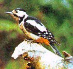
Birds (Resident or seen foraging on site.)
|
Wren |
Dipper |
|
Kingfisher |
Grey Wagtail |
|
Pied Wagtail |
Tree creeper |
|
Sand martin |
Swallow |
|
Swift |
House Martin |
|
Gold crest |
Chiff chaff |
|
Garden warbler |
Black cap |
|
Blue tit |
Coal tit |
|
Great tit |
Long tailed tit |
|
Sparrow |
Greenfinch |
|
Chaffinch |
Bullfinch |
|
Goldfinch |
Yellow hammer |
|
Siskin |
Redpoll |
|
Hedge sparrow |
Robin |
|
Starling |
Black bird |
|
Song thrush |
Mistle thrush |
|
Red wing |
Field fare |
|
Greater spotted woodpecker |
Green woodpecker |
|
Collared dove |
Pigeon |
|
Wood pigeon |
Mallard |
|
Pheasant |
Magpie |
|
Jackdaw |
Rook |
|
Crow |
Tawny owl |
|
Sparrow hawk |
Buzzard |
|
Grey heron |
Green parrot sp. (Escaped bird regularly seen flying around Mill Buildings this Spring.) |
Amphibians
Common frog
Common toad
Smooth newt
Invertebrates
The site, due to its habitat diversity, is likely to have large and varied invertebrate fauna which has not yet been surveyed. The following species have been noted on and around the site through casual observation:-
Butterflies
|
Peacock |
Small tortoiseshell |
|
Red Admiral |
Ringlet |
|
Brown argus |
Meadow brown |
|
Orange tip |
Purple hairstreak |
|
Small white |
|
Convolvulus hawk moth
Comments and Management Suggestions
Springfield Mill has a variety of semi-natural habitats and as can be seen from the species lists a great diversity of wildlife. Some of the species present are uncommon. The presence of naturally regenerating native woodland is in itself fairly unusual. The site should not be viewed in isolation but as part of the North Esk- Bilston Glen wilderness area. Species diversity i.e. the number of species present is directly proportional to the area of habitat available and with 6ha of relatively undisturbed and varied habitat Springfield Mill must be viewed as making a valuable contribution. Any habitat loss and increase in disturbance from human habitation on the site could only be detrimental to plant and animal life.
Were Springfield Mill to be developed as a wildlife area then there are improvements could be made although the quality for wildlife of the site is already high. The clearance of buildings and crushing of rubble will be necessary to make the site safe (although strictly speaking buildings would be better left to crumble over time as far as floral and faunal inhabitants are concerned). Crushed rubble could be recolinised from surrounding land or sewn with suitable seed mixes and planted with native tree species. Berry bearing varieties such as Hawthorn, Crataegus monogyna, or Rowan, Sorbus aucuparia, would provide food for birds.
One notable feature of this site is the scarcity of the invasive species (brought into the country mainly by Victorian plant collectors) which have overtaken many of the urban wildlife areas e.g. the disused cemeteries and Water of Leith in Edinburgh. Himalayan Balsam, Impatiens glandulifera, and Giant Hogweed, Heracleum mantegazzianum, are completely absent and only one or two specimens of Japanese Knotweed (Fallopia japonica), Rhododendron ponticum and Snowberry (Symphoricarpus albus) were found. Encouragingly there is much woodland regeneration and the species involved are largely native. Only a little sycamore regeneration has been observed. A management priority for the site should be to remove all the invasives mentioned and to gradually replace mature sycamores with natives e.g. oak, Quercus petraea.
In the woodland fallen and felled wood should continue to be left to decompose as it harbours many invertebrate species which have an important part to play in the food web. Erection of bird and bat boxes would encourage breeding and the latter might go some way to compensating for the loss of the bat roost in one of the two remaining buildings were this demolished.
The large fish pond on site is all but completely in-filled. The creation of small pools in the remaining marshy area will ensure the survival of the area’s amphibian population.
Were the site to be developed as a wildlife area a comprehensive management plan should be devised.
Educational Value of the Site.
As a resource for the teaching of ecology the site offers a wide range of habitats within easy reach of Lasswade High School and the primary schools of Loanhead, Bonnyrigg and Lasswade. Many aspects of the curriculum could be covered through study of the area.
Contributors to the Wildlife Survey
Scottish Wildlife Trust- Stuart Maxwell
Royal Botanic Garden, Edinburgh- Dr. James Ratter
Royal Botanic Garden Edinburgh- Douglas Mc Kean
SMAG- Alan Hulme M.Sc. Plant Taxonomy, Dip. Hort. Kew.
SMAG- Alison Hulme M.Sc. Natural Resource Management, B.Sc.(Hons.) Zool., PGCSE.
Report prepared 12th July 1999.
Tree survey of Springfield Mill site
Date of survey: 11th July 1999
Carried out by: Alan Hulme M.Sc., DipHort(Kew)Hons, R.F.S.Cert.Arb. of Hulme Horticultural
The survey was carried out to establish which species are present on the site, the relative proportions of these species in different zones, size of mature specimens (measured by girth at breast height) and to record details of regeneration. For the purpose of this survey the site was divided into 5 zones (see map).
Zone 1
|
Species |
Percentage cover |
|
Betula pendula |
44% |
|
Salix caprea |
50% |
|
Fraxinus excelsior |
2% |
|
Ulmus glabra |
2% |
|
Acer pseudoplatanus |
2% |
Zone 2
|
Species |
Percentage cover |
|
Alnus glutinosa |
10% |
|
Betula pendula |
40% |
|
Salix caprea |
35% |
|
Ulmus glabra |
10% |
|
Acer pseudoplatanus |
5% |
Zone 3
|
Species |
Percentage cover |
|
Betula pendula |
40% |
|
Salix caprea |
2% |
|
Fraxinus excelsior |
15% |
|
Ulmus glabra |
2% |
|
Acer pseudoplatanus |
40% |
|
Crataegus monogyna |
1% |
Zone 4
|
Species |
Percentage cover |
|
Betula pendula |
3% |
|
Salix caprea |
20% |
|
Fraxinus excelsior |
20% |
|
Ulmus glabra |
10% |
|
Acer pseudoplatanus |
30% |
|
Sorbus aucuparia |
5% |
|
Crataegus monogyna |
2% |
|
Sambucus nigra |
10% |
Zone 5
|
Species |
Percentage cover |
|
Betula pendula |
25% |
|
Salix caprea |
25% |
|
Acer pseudoplatanus |
30% |
|
Taxus baccata |
5% |
|
Ilex aquifolium |
10% |
|
Sorbus aucuparia |
3% |
|
Aesculus hippocastanum |
2% |
It can be seen from the above data that the species mix in each zone is quite different. This is probably a result of differing soil types, topography and management. Much regeneration is present across the site as a whole. This is particularly noticeable along the river side where Alnus glutinosa, Salix caprea, Ulmus glabra and Fraxinus excelsior are competing for space. In more open areas the regenerating species are predominantly Betula pendula and Salix caprea.
Specimen trees
A variety of mature trees are present across the site. Some of these have been planted, others have probably arisen opportunistically. Girth at Breast Height was recorded for each tree where possible to give an indication of size and a reference for measuring growth and vigour in the future. The trees are represented by lower case letters on the map and are as follows:
|
Letter |
Species |
Girth at Breast |
|
a |
Betula pendula |
0.94 |
|
b |
Salix caprea & B.pendula growing on building wall |
|
|
C |
Acer pseudoplatanus (multi stemmed) |
1.80 |
|
D1 |
Acer pseudoplatanus |
2.65 |
|
d2 |
Acer pseudoplatanus |
2.38 |
|
d3 |
Fraxinus excelsior |
ivy covered |
|
e |
Acer pseudoplatanus |
2.90 |
|
f |
Acer pseudoplatanus |
3.30 |
|
g |
Acer pseudoplatanus |
3.31 |
|
h |
Aesculus hippocastanum (multi stemmed) |
1.35 average |
|
|
(NB growing through metal tree guard) |
|
|
i |
Tilia x europaea |
much epicormic growth |
|
j |
Fagus sylvatica |
2.95 |
|
k |
Tilia x europaea |
4.21 |
|
l |
Acer pseudoplatanus |
1.87 |
|
m |
Acer pseudoplatanus |
2.13 |
|
n |
Acer pseudoplatanus |
2.15 |
|
o |
Araucaria araucana |
1.50 |
|
p |
Abies sp. |
|
|
q |
Fagus sylvatica purpurea |
2.93 |
|
r |
Araucaria araucana |
3.02 |
|
s |
Picea abies |
2.36 |
|
t |
Tilia x europaea |
2.8 |