|
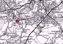
1 Introduction 1.1 Springfield Mill is located in the valley of the North Esk to the west of Polton Village (see Figure 1). It is a former industrial site, of approximately 6 hectares, which now lays derelict. The Site is identified in the Draft Midlothian Local Plan as being a site suitable for 25 houses (Appendix D: Established Housing Land Supply, Midlothian Local Plan Consultative Draft). The majority of the Site is in the ownership of Midlothian Council, with a small part close to the river being owned by James McNeil Properties Ltd. 1.2 The Springfield Mill Action Group (SMAG) was formed in May 1999 to promote the use of the Site as a wildlife site and as an alternative to proposed housing development. The Group have campaigned for the removal of the Site from the Register of Housing Land Supply in the new local plan and submitted a proposal for Springfield Mill Wildlife Site to Midlothian Council in July 1999. 1.3 SMAG commissioned the Turnbull Jeffrey Partnership on September 13th 1999 to undertake a more detailed proposal for the Springfield Mill Wildlife Site, following the award of a grant from Midlothian Council. In view of the complexities of the site, the Turnbull Jeffrey Partnership put together a study team comprising the following professionals;
1.4 The aim of the Springfield Mill Wildlife Site proposal is to preserve and enhance the value of Springfield Mill to wildlife and people. Key objectives set by the Group to realise this aim are;
1.5 The principal matters which needed to be addressed by the study include;
Available Information on the Site 1.6 A number of site investigations and surveys have been undertaken of the Springfield Mill site. Those of relevance to this proposal include:
1.7 The Group had also undertaken preliminary consultations with a demolition contractor to ascertain likely costs for demolition of structures, crushing of debris on the site and removal of some materials off site. These costs formed part of their initial proposal submitted in July 1999 to Midlothian Council. Study Methodology 1.8 Due to time and budget constraints, no new scientific testing or investigative survey of the site has been undertaken to inform these more detailed proposals for the wildlife site. A review of the existing survey information on the site has been undertaken by the specialists on the study team. Limitations in this survey information are identified as part of the review and some of the recommendations outlined in this study will be subject to more detailed survey should the proposal progress. 1.9 The principal tasks which have been undertaken by the study team include:
|
|||
|
The Proposal Site Appraisal 2.1 An appraisal has been undertaken of the Site and is contained in Appendix A. The appraisal outlines the historical background to the Site and considers the landscape character and ecological interest of the Site. A review of existing ground survey data and risk assessment with regard to contamination of parts of the Site is outlined in the appraisal. The appraisal also considers the hydrological issues associated with the North Esk and the importance of the Site in potentially preventing flooding downstream. 2.2 The appraisal of the Site, its condition and its overall context within the North Esk valley, has allowed us to identify key issues to be addressed by a landscape strategy for the future creation of a wildlife site at Springfield Mill. Opportunities Presented by the Site 2.3 The appraisal undertaken has shown that the Site offers great potential for establishing a wildlife reserve due to its location within the North Esk valley, an area of high nature conservation and landscape value. The proposed use of the Site would conserve and enhance the existing features of nature conservation interest on the Site, such as woodland. The proposal would also increase the habitat diversity found within this section of the North Esk valley through provision of grassland and wetland features. 2.4 The Site has an interesting historical focus stemming from its origins as the designed policies associated with Glenesk House and long use for paper milling. The Site plays an important role in the context of the significant architectural and industrial heritage of the North Esk Valley. Conservation of elements of this heritage on the Site, offers opportunities for exciting interpretation and education in the future. Key Issues 2.5 The industrial legacy of the Site has however resulted in ground contamination identified in the waste mound and the former gas works site. The legislation relevant to the proposed use of the Site as a wildlife reserve would merit less onerous treatment of potential pollutants than would land intended for construction of housing. With this in mind the risks of pollution to humans associated with the waste mound would not be significant if left intact. 2.6 The flooding history of this stretch of the North Esk is also an issue, which needs serious consideration, particularly in view of the potential for flooding damage further downstream. 2.7 At present the Site poses a health and safety risk in terms of the dereliction of existing buildings and unsafe piles of demolition rubble. Health and safety aspects therefore need to be considered in creating the wildlife site and in the treatment of existing features, which contribute to that risk. 2.8 In summary therefore, the key issues, which will need to be resolved in planning and creating the wildlife reserve, will be;
Objectives 2.9 The following objectives have been set by the Group for the Springfield Mill Wildlife Site;
2.10 In achieving these objectives in the long term, the key issues identified need to be resolved in planning works to be done on the Site. 2.11 In addition, funding will need to be sought for the scheme and works therefore need to be cost effective and the proposal achievable. This has a bearing on the planning of the wildlife site and the operations needed to create new habitats and other features. Short Term Strategy 2.12 The short term strategy for developing the Site as a wildlife reserve will be to address the key issues of flood prevention, treatment of contamination and health and safety aspects in the most cost effective and sustainable manner. Resolution of flooding problems 2.13 Given the history of flooding on the Site and downstream, it is essential that accommodation for possible future flood occurrences should be made available. The Site offers an important opportunity for this, being one of the few areas of low lying and undeveloped ground along this stretch of the North Esk valley. Measures to accommodate such flood occurrences would therefore assist in safeguarding other more sensitive built areas downstream. 2.14 As stated in the introduction to the Scottish Executive’s "National Planning Policy Guideline NPPG7 – Planning and Flooding" "…Flooding is a natural phenomenon which plays an important role in shaping the natural environment and cannot entirely be prevented. The Government however wishes to ensure that flood risk is properly taken into account in the planning of developments and that measures are taken to reduce the risk of flooding and the damage which floods cause…" NPPG7 goes on further to state (at paragraph 19):- "…Development of an area which is exposed to frequent or extensive flooding is likely to be unsustainable and should be avoided…" 2.15 Having regard to the general advice given in NPPG7, the history of flooding in the locality and the location of the subject site, it can only be recommended that the site’s role in acting as a natural flood defence should be retained if not enhanced. In other words nature should be accommodated and areas surrounding the subject site should be protected in its retention as part of the flood plain. The Springfield Mill Action Group’s proposals offer a positive management and protection in this regard 2.16 In principle, this recommendation is best achieved if the existing low level areas are not altered, thus ensuring that the existing ‘wash land’ is safeguarded. In this regard it is essential that the two weirs close to the Site, are properly safeguarded and maintained to ensure that potential flooding of land at lower levels of the River North Esk is minimised. 2.17 In creating the ‘wash land’, excess fill material should be located to the south of the Site, adjacent to existing high level areas. This should include the relocation of existing spoil material which effectively forms a long bund parallel to the river where mill buildings have been demolished, as this would impede the ability of flood water to flow over the lower part of the Site. 2.18 In general terms the existing landform of the Site slopes in a series of tiers towards the river. References to the recorded levels information suggests that, if the northern part of the site is maintained at a level of 73.5m AOD, or less, it would result in a useful ‘wash land’ being made available, this probably extending up to about 20% to 25% of the Site. 2.19 The creation of a ‘wash land’ would also provide a suitable alternative ‘channel’ for the North Esk, albeit at a relative higher level to the existing river, should Hewan Bank suffer further slippage in the future blocking the existing course of the river. Treatment of contamination 2.20 While contamination was identified in the southern areas of the Site, including the waste mound and woodland, it is considered that this does not pose a significant risk to humans as it is well covered with mature vegetation. The recommended approach therefore will be to leave the contamination in situ and not disturb the vegetation cover. 2.21 There are three remaining issues of potential concern with regard to contamination on the Site however and these are:
The following recommendations to treat the known contamination on Site and to undertake further assessment to clarify whether treatment will be necessary are proposed: Asbestos 2.22 The first requirement is to further investigate the Site in order to determine the extent of the asbestos contamination, and estimate the quantity and nature of the asbestos material present and assess any immediate health risks to current users at the site. An asbestos walkover survey to inspect demolition waste, and remove any asbestos from the stockpiles of rubble prior to any crushing of the material is advised. A full asbestos survey of the existing building prior to demolition should also be undertaken, and if any asbestos is found, a licensed contractor should remove it, and dispose of it in accordance with appropriate waste management legislation. 2.23 It is recommended that the demolition stockpile should not be disturbed, and in particular no crushing of the rubble should be undertaken until an asbestos survey has been undertaken, and precautions are taken to prevent exposure of workers and the public to asbestos. Contamination at the Former Gasworks Site 2.24 The area of the former gasworks in the north west corner of the Site, adjacent to the river does not have sufficient cover to minimise any health risks to future users of the Site. It is therefore recommended that an additional barrier be provided on top of the soil contaminants. Such a barrier should be covered with about half a metre of capping materials, to provide a barrier to humans. There will be minimal costs, assuming the cap layer can consist of the crushed rubble from elsewhere on site. 2.25 The options for dealing with the soil contaminants, will however, be subject to regulatory approval from Midlothian Council Environmental Health Department, and SEPA. As indicated above, SEPA are likely to request further investigative works to show there is no risk of sub-surface movement of the contaminants and in turn no effect on internal water features or external controlled waters such as the river. If a properly engineered capping layer with associated drainage systems would need to be designed, supervised and properly installed, costs for capping would be considerably increased. Any need to remove contaminated spoil off site would also incur substantial costs above this. However, it would appear unlikely that this will be the case. Potential Groundwater and River Contamination 2.26 Further works are needed at the Site to address the impact of the contaminated land on the groundwater and river. The risks of contaminants leaching from the soil to the groundwater phase, impacting on internal water features (current and proposed pond) and eventually entering the river has not been fully assessed. There is in general a lack of reliable groundwater data in the investigation work conducted to date. In view of this, the following works are proposed:
2.27 Depending on the nature of the contamination, further works to remediate the Site may be necessary. However, on the basis of the water quality analysis undertaken by SEPA which shows no adverse impact on the river downstream, it is considered unlikely that further measures will need to be undertaken, although it will be important to undertake additional groundwater and river survey to confirm this view. Long Term Strategy 2.28 Increasing bio-diversity of the Site
2.29 Increasing amenity value
2.30 Encouraging Community Participation
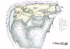
2.31 SMAG intend to liaise with Midlothian Countryside Ranger Service and Scottish Wildlife Trust to organise mini-beast hunts, wildlife clubs, pond and river dipping and plant forages The Landscape Masterplan 2.32 The landscape masterplan has been devised as a team effort with landscape architect, hydrologist and quantity surveyor working together to interpret the objectives set by SMAG and to resolve the key issues associated with the Site. The masterplan seeks to conserve and enhance existing features of landscape or nature conservation interest, accommodate flooding thus providing benefits to sensitive built areas downstream and has been planned to provide low cost reclamation of the Site. 2.33 An indicative masterplan is shown in Figure 2. Mature woodland would be retained on the southern part of the Site and managed in the long term to increase bio-diversity. Improvements to footpaths would be undertaken in this area and obvious fly tipped material would be removed. Bat boxes (to be confirmed with SNH) would be positioned on trees within this area (possibly in a defined area not likely to be disturbed by management operations and people). 2.34 Existing buildings would be demolished and spoil material shifted on the Site to create a ‘wash land’ area close to the river and higher mounded areas to the south. A barrier would be erected along the public road to secure the site, give it definition and preventing access for unauthorised vehicles. An additional parking area accommodating up to 6 vehicles would be provided within the Site to ease congestion on the road and improve access for visitors, such as school parties and the less able. A map and interpretation of the Site would be provided close to the main pedestrian entrance which would outline the historical context of the Site, its nature conservation interest, and footpath routes within the wider North Esk valley. 2.35 A simple footpath system would be created, based on existing concrete hardstanding and paths, providing a variety of circular routes around the Site through the different habitats created. Wheelchair access would be provided on the lower riverside path and around the newly created wetland habitats. The former pond would become a valuable wildlife habitat and educational resource with small pools and wetland habitats created in the depression. 2.36 Native tree and shrub planting would be undertaken in pockets over the Site, to provide a diversity of habitats for wildlife as well as a variety of spatial experiences for the user. The majority of the northern ‘reclaimed’ area would be seeded onto crushed spoil material with meadow grass and wildflowers. The area adjacent to the river would be used as a ‘wash land’ and would be subject to sporadic flooding from the North Esk. The river is an important feature of the site and to increase access to it, a viewing/access area would be created next to the bank, which could be utilised by visitors to the Site. Landscape Management Plan 2.37 A long-term management strategy has been drafted for the Wildlife Site and this is contained within Appendix C. |
|||
|
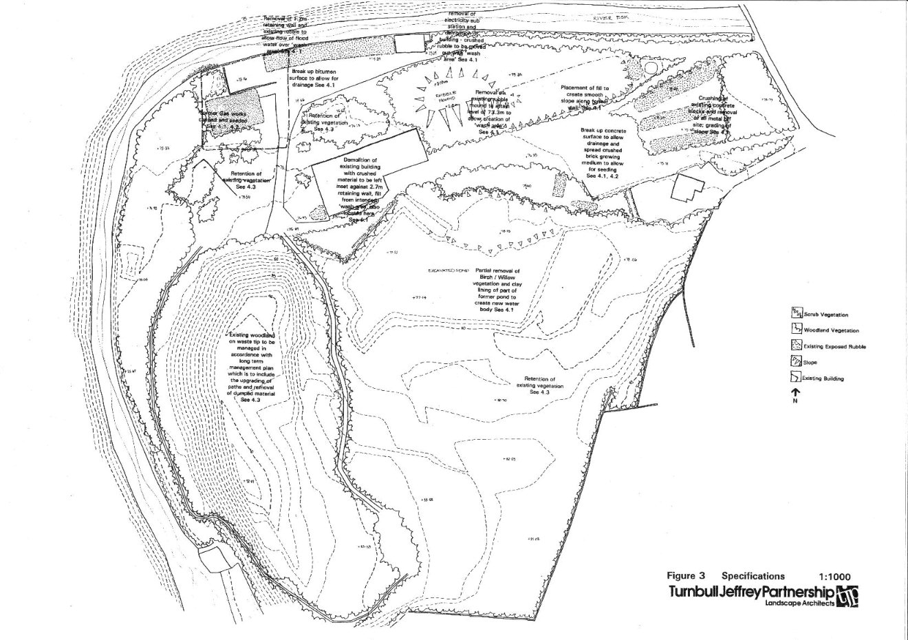
3 Method Statement3.1 Many of the measures outlined in this method statement are indicated on Figure 3 – Outline Specifications. Additional investigations/survey Asbestos walkover survey 3.2 An asbestos walkover survey will be undertaken to inspect demolition waste, and remove any asbestos from the stockpiles of rubble prior to any crushing of the material. A full asbestos survey of the existing mill building prior to demolition will also be undertaken. Bat survey 3.3 Sound survey to determine species of bat within former mill building. Consultation with Scottish Natural Heritage on basis of survey report to obtain consents for demolition and discuss suitable mitigation measures. Groundwater/river survey 3.4 Investigation to assess the nature and extent of contamination in groundwater involving the excavation of five boreholes in the vicinity of the former gas works site and analysis of selected soil and groundwater samples. 3.5 A survey of the river bed, including sampling benthic invertebrates from upstream, midstream and downstream of the site is recommended. The benthic survey results will assist in assessing any impact of the site on the river fauna. Consultation with SEPA to confirm measures to be used to reduce risk to humans of contaminants associated with the former gasworks site and whether any further measures need to be taken with regard to potential groundwater/river contamination. Demolition Works Removal of asbestos 3.6 All visible asbestos will be removed off Site by a licensed contractor and disposed of in accordance with appropriate waste management legislation. Demolition of existing buildings 3.7 Removal of all metal in these buildings and on site (where either loose or if metal reinforcement standing proud from concrete blocks etc) Capping of former gas works 3.8 Provision of an additional barrier on top of the soil contaminants in the area of the former gas works (see figure 3). Such a barrier should be covered with about half a metre of capping materials, to provide a barrier to humans. There will be minimal costs, assuming the cap layer can consist of the crushed rubble from elsewhere on site. Earthworks Shifting of rubble 3.9 From demolished buildings and existing piled material along riverside to lower area in centre of site, as indicated on Figure 3. Creation of growing Medium 3.10 The areas of brick and rubble may be used for planting directly, preventing the need to import expensive topsoil. The rubble will be passed through a stone crusher, reducing it to a granular material, and then used as a sub base or for capping. The fine dust, produced as a by-product from the crushing process, will then be spread as a 120mm top layer suitable for direct seeding. The brick and mortar rubble may contain phosphorus, potassium, magnesium and calcium making it a suitable growing medium. Seeding/Planting Works 3.11 Provision of nitrogen is important in establishing vegetation. The fixation of nitrogen by some plants offers a cheap and sustained source, so legumes and Alders will be included in the species. Areas of mounding will be seeded with a grass clover mix. Legumes must be inoculated by Rhizobium bacteria in order to fix nitrogen, which is absent from many derelict land sites. Clover seed may however be purchased ready-coated which gives greater reliability and convenience. The seedbed should be fine enough to allow seed to be covered to a depth of 10-20mm either by harrowing or by natural burial in crevices by rainfall. Rates of seeding 50-100kg/ ha should be used to allow for some losses due to overdeep and shallow burial. Fertiliser 3.12 Addition of fertiliser to the seed application frequently causes severely reduced germination of the legumes such as clover, which are essential to the long-term nutrition of the sward. With the exception of slowly soluble fertiliser, the application of fertiliser should be delayed vegetation has established, around six weeks after seeding. Tree Planting 3.13 Planting of native trees and shrubs will take place in approximately 20% of the reclaimed area of the Site to increase the wildlife habitats and provide visual enhancement. A 50:50 mix of nurse and climax species is advised with Alder included in the mix. Pockets for planting will be created within rubble and filled with a mix of organic material (imported) and crushed brick. Transplants and whips will be used, as they will give better long-term growth than larger stock. Nutrients and Mulching 3.14 The addition of mulch and nutrients at the time of planting will greatly aid the establishment of trees/shrubs. As the trees are being planted in coarse material, up to 240g of slow release fertiliser (e.g. Enmag) may be required per tree. Mulching will improve soil moisture conditions, reduce extremes of temperature and suppress weed growth. Granular material, possibly a wood chip mulch created from the thinnings of existing Sycamore on the Site, should be included at the time of planting and spread to a diameter of 0.7-1m around the tree and to a depth of 50mm. Creation of paths 3.15 Using existing hard standing as base, edges of concrete broken up blinded with crushed brick tilth / subsoil mix to form 1.5m wide path and seeded. Management During Establishment Period 3.16 The scheme will be designed for minimal maintenance from the outset however, longer-term management will also be needed. The management programme can be divided into two phases; the establishment phase, years 0-5, and the long-term management stage from year 5 onwards. Both stages are important to the success of the planting and wildlife capabilities of the site. Nutrient Additions 3.17 Regular checks should be carried out to ensure the health of the plants and an application of fertiliser on planted areas on the reclaimed area in the third year will be important as the trees are growing on a skeletal material without soil cover. Weed Control 3.18 Weed control is the single most important aspect of aftercare. If the weeds are not eliminated then the trees will be competing for moisture, nutrients and light. Weeds will be controlled at the start of the growing season and a 1 metre diameter weed free area left around the transplants. Replacement of Plant Material 3.19 Provision will be made for replacement of failed or vandalised stock during this period. Long Term Management Thinning 3.20 The existing mature woodland should be managed to create a mix of native species, with the systematic removal of invasive Sycamore. The newer planting may also require thinning at 8-10years and again at 15-25 years dependant on the species. Thinned timber could be utilised as wood chippings to provide material for upgrading footpaths in the existing woodland on the Site. Wood chippings could also provide a mulch for newly planted areas with the reclaimed part of the Site, where evaporation loss could be reduced. Creation of Pools/Wetland Habitats 3.21 Volunteer groups would carry out the creation of wetland habitats within the former pond. Small pools to be created within the depression would need to be constructed with a clay lining to prevent any ground water contamination from the waste mound area on the Site. |
|||
|
4.1 A preliminary cost estimate is outlined in the following table: |
|||
|
Demolition and site clearance |
|
||
|
Bat survey and relocation |
2,000.00 |
||
|
Demolish structures |
45,000.00 |
||
|
Crush arisings |
6,000.00 |
||
|
Crush existing stockpiled rubble |
22,000.00 |
||
|
General clearance |
2,500.00 |
||
|
Reduce height of wall next river |
1,500.00 |
||
|
Contaminated land |
|
||
|
Groundwater/river surveys |
15,000.00 |
||
|
Crushed rubble capping to former gas works |
1,500.00 |
||
|
Asbestos survey |
1,000.00 |
||
|
Remove asbestos from rubble |
8,000.00 |
||
|
Earthworks |
|
||
|
Spread crushed demolition rubble |
5,000.00 |
||
|
Relocate rubble and form mounds |
10,000.00 |
||
|
Blind rubble with fines |
2,000.00 |
||
|
Import and fill low grade topsoil for planting pockets |
5,000.00 |
||
|
Break up concrete and bitmac paving |
10,000.00 |
||
|
Footpaths, car parking and viewpoint |
8,000.00 |
||
|
Fencing |
|
||
|
Boundary fence and entrance gates |
1,500.00 |
||
|
Signage |
2,250.00 |
||
|
Footpath and verge |
750.00 |
||
|
Seeding and Planting |
|
||
|
Seeding grass/clover mix on crushed rubble |
12,000.00 |
||
|
Native shrub/tree planting |
7,500.00 |
||
|
Management for 5 years |
|
||
|
Survey and Report on woodland |
500.00 |
||
|
Maintenance of new seeding/planting |
4,000.00 |
||
|
Management of mature woodland |
4,000.00 |
||
|
Create pools/wetland habitats using volunteer labour |
5,000.00 |
||
|
TOTAL ESTIMATED COST |
£182,000 |
||
|
4.2 The cost estimate outlined in the table above is exclusive of the following:
4.3 It has been assumed that volunteer labour is free of charge with materials and some supervision only being costed. While it is possible that some topsoil may be donated to the Site, no allowance has been made in the cost estimate for this. 4.4 Demolition and site clearance costs have been based on estimates prepared by Scotdem, in response to a written outline specification for the works. Costs for contaminated land survey and treatments have been based on estimates provided by EAG Environ. Assumptions have been made in the proposals with regard to the treatment likely to be required for the former gasworks site. Costs for alternative measures such as clay capping or removal of contaminated spoil will be dependent on additional survey and analysis and have therefore not been set out at this stage. |
|||
|
Appendix A: Site Appraisal Context of the Site A.1 The Springfield Mill site is located in the North Esk valley to the west of Polton village. It lies down river from the Roslin Glen Nature Reserve, which is managed by the Scottish Wildlife Trust, and the proposed Roslin Glen Country Park. Hewan Bank Site of Special Scientific Interest (SSSI) lies on the western bank of the North Esk opposite the Site, as does the North Esk Walkway. The Site lies within an Area of Great Landscape Value (AGLV) as identified in the Midlothian Local Plan. A.2 The Site lies at the start of a 2.5km stretch of the river valley, which is largely inaccessible by vehicles with no public roads or bridging points and little habitation. This section of the valley is densely wooded, with sheer slopes down to the river. Historical Background A.3 Glenesk House and its policies originally occupied the Site with the first paper mill being located within these policies close to the North Esk in 1742. Although Glenesk House is not now in existence, many large specimen trees occur on the Site and date from plantings undertaken in the late 1800’s. The policies of Glenesk House included an ornamental pond and the depression of this is still visible on the Site. A.4 During the early part of this century, Polton Village was a thriving industrial community with two working paper mills serviced by a railway. Waste material from the mills appears to have been dumped from the late 19th century, on the western part of the Site creating a steep sided mound. This mound is now covered with mature sycamore woodland. The ornamental pond, which formed part of the designed landscape of Glenesk House, was also later used as a reservoir for industry on the Site. A.5 Springfield Mill ceased production by the late 1960’s and the Site became the property of Lothian Region and Midlothian District Council in 1975. Prior to 1979, the main site offices and two warehouses were used by the District’s Technical Services and Housing Department and the Region’s Highway’s Department used part of the area for an open storage yard. The remainder of the buildings and yards on the mill site (some of which were in private ownership) were occupied by a variety of local businesses up until 1990. A number of derelict buildings were demolished around this time and areas of rubble and hard standing left on the Site.
Present Use of the Site A.6 The Site is currently derelict with two buildings remaining; a large former mill and part of a former terrace of stone faced buildings close to the river. The latter building houses an electricity sub-station and is owned by Scottish Power. An electricity connection still exists between the sub-station and the remaining large mill building on the Site. Scottish Power have been consulted with regard to the status of the sub-station and have confirmed (see Appendix A) that the owners of the Site would need to make a request to them to have the power disconnected to the mill, prior to any relocation or removal of the sub-station. A charge may be made by Scottish Power for removal or relocation of the supply, although it is understood that this fee may be waived if the Site were to be used as a wildlife reserve. A.7 While the Site is no longer used for storage or industry and is effectively ‘derelict’, many local people currently use the area for walking and quiet recreation. Landscape Character A.8 The Site can be split into the following distinct areas of landscape character:
These landscape character areas are illustrated in the following figure. Nature Conservation Interest A.9 Phase One and Two Habitat Surveys have been undertaken of the Site and these are available as separate documents, which can be obtained from SMAG. A.10 The Site is of considerable interest to wildlife. Approximately 4ha of the Site is wooded, making a significant contribution to the Roslin Glen to Bilston Glen semi-natural woodland area. This woodland and regenerating birch, elm and willow scrub provide habitat for nesting songbirds, insects and mammals. Mammals present on the Site include badgers, roe deer, foxes and small rodents. Small pools which exist seasonally within the former pond support a variety of wildlife including frogs, smooth newts and toads, although these are progressively drying out due to natural siltation. A.11 The derelict part of the Site provides both grassland and ruderal habitats. There is a variety of flora including spotted orchids, mullein, toadflax and a diversity of other plants which provide fodder for many insects among them butterflies such as the red admiral, peacock, small tortoiseshell and rare visitors such as the convolvulus hawk moth and the purple hair streak butterfly. The river walls provide a vantage for the resident kingfishers and the river itself is home to dippers, pied and grey wagtails, brown trout, eels and the plethora of invertebrates which inhabit any such healthy, fast flowing watercourse. Sand martins nesting in Hewan Bank and sparrow hawks also use the Site. A.12 Bats are present in the large mill building remaining on the Site. The species of bat present is not known and survey would need to be undertaken prior to any detailed mitigation measures being considered in terms of the proposed demolition works and the provision of alternative roosts. Consultation will be undertaken with SNH to clarify the situation with regard to the protection of bats under the Wildlife and Countryside Act 1981. The health and safety aspects associated with the derelict mill building are likely to influence SNH to agree to its demolition providing adequate mitigation measures can be ensured. Contamination of the Site Introduction A.13 The contamination appraisal of the Site is based on a review of previous site investigation reports, and observations made during a site visit undertaken on 23rd September 1999. No additional soil sampling or analysis of soil, water or other material was undertaken as part of this appraisal. A.14 Historically, there has been a number of potentially contaminating activities at the Site including the following:
A.15 In relation to the environmental setting of the site, the River North Esk forms the western and northern boundaries of the Site, and is prone to flooding across the low-lying parts of the site. A geological SSSI, Hewan Bank, is adjacent to the northwest of the site, and the nearest residential premises are adjacent to the eastern site boundary. Review of previous studies A.16 Two previous site investigations have been undertaken at the Site and are summarised as follows: A.17 The Lothian Regional Council undertook an investigation in December 1985 to identify if the former Springfield and Polton mills could be rehabilitated for housing sites. The investigation comprised 6 boreholes and 6 trial pits, all excavated on the central and southern parts of the site, in the vicinity of the pond and the mound of spoil. Nine soil samples were analysed for a range of parameters including pH, moisture, total solids, total alkalinity, ash content, inorganics (sodium, potassium, and sulphate), and metals (lead, cadmium, zinc, aluminium, arsenic and mercury). A.18 In 1992, WA Fairhurst & Partners undertook a desk study, site inspection and site investigation comprising thirty-two trial pits, two trial trenches and fourteen boreholes. In total, 119 soil and 15 groundwater samples were analysed for a range of parameters. The analysis included pH, calorific value, oxidising agents, inorganics (fluoride, sulphide, sulphite, sulphates, total nitrogen, ammonia, phosphates, cyanides), organics (toluene extractable matter, phenols, formaldehyde) and metals (arsenic, antimony, barium, cadmium, chromium, copper, lead, mercury, nickel and zinc). In addition, three samples of water were taken from the river and two samples from the pond, to assess any impact on surface water quality from leachate/run-off from the site. A.19 The surveys confirmed the depth of fill varied between 0.3m-3.6m thick within the pond area, up to 15.25m within the mound area, and between 0.3-5.45m thick elsewhere. The fill comprises a clayey sand and gravel that contains lenses of paper waste, wood and other organic debris. In addition ash, coal, blaes, burnt shale, polythene, porcelain, brick, concrete and metal fragments are present within the fill. Alluvial deposits of sand and gravel, with bands of sandy clay underlay the fill. Groundwater appears perched within the fill at depths of between 0.65m – 3.6m bgl. Standing water was also measured at depths of between 1.6m – 14.7m bgl within the natural strata of sand and gravels. Groundwater elevation contour plots indicate groundwater movement is generally towards the river. Contaminants in Soil A.20 In view of the proposed use of the Site as a Wildlife Site, the analytical results from previous site investigations have been assessed against Interdepartmental Committee on the Redevelopment of Contaminated Land (ICRCL) Guidelines for landscaped areas and open space. These are less stringent controls than would be applied to land, which would be developed for housing. A.21 Overall, soil contamination was not widespread across the site and was restricted to the former gasworks and two areas of buried waste namely in the mound and in land to the south of the former Glenesk house, with contaminants restricted to the fill material. Contaminants in Groundwater A.22 The groundwater at the Site has not been adequately assessed by the previous surveys, with the majority of water samples taken from trial pits for analysis, rather than from properly installed boreholes. In addition oil contamination was visually recorded on trial pit logs at five locations adjacent to the north of the mound. The contamination was described as discoloured black water, with an oily appearance, which could be indicative of leachate from the mound. No analysis for hydrocarbons was undertaken on these water samples. A.23 The groundwater results have been assessed against the Dutch Intervention guidelines, which although they do not have legal status in the UK, are widely used for assessment purposes. In addition, leachate completion criteria have been used for assessment purposes, given the mound of waste at the Site. The river North Esk flows adjacent to the site and is likely to be in hydraulic continuity with the groundwater from the site. Environmental quality standards (EQS) and surface water classification guidelines have also been used for assessment, and essentially represent ‘clean’ levels. EQS are set for protection of aquatic life from dangerous substances and surface water classification guidelines are set for abstraction of drinking water supply. Conclusions A.24 Based on the findings of the site investigation, there are a number of risks posed by the Site in its current form. Contamination is present within fill materials at the Site and "pollutant linkage" may exist, as defined in the draft guidance on contaminated land. The regulations to implement the provisions of Part IIA of the Environmental Protection Act 1990 will shortly be laid, with the regime entering into force in April 2000. In this regard the following assessment of risks is presented; Soil Contaminants A.25 Chemical analysis results show the soil phase is contaminated with elevated levels of metals (lead, arsenic, barium, antimony, copper, nickel and zinc), toluene extract and sulphate. The contaminants are associated with the ash fill material and are localised on the western part of the site, in the vicinity of the mound, and former gas works site. The soil contaminants are unlikely to pose a risk to future users at the Site, provided the mature vegetation within the mound area is left in situ, which reduces the pathway for exposure, and that the gasworks area, where contamination was detected at shallow depth within the soil profile, has an additional layer of material to cover it. Water Contaminants A.26 The contaminant of greatest concern observed in groundwater was the indication of oily water in several of the trial pits located down gradient of the mound. Hydrocarbons are classed as a List I (black list) dangerous substance. Under section 30F of the Control of Pollution Act 1974, it is an offence to cause or knowingly permit any poisonous, noxious or polluting matter to enter any controlled waters without consent. Under the new Groundwater Regulations 1998, SEPA have powers to issue a notice to prevent or control indirect discharges of hydrocarbons to groundwater. Steps to further assess the hydrocarbon contamination in groundwater are likely to be required by SEPA, and if there is a significant risk of pollution, then clean up of the groundwater may be required. A.27 Other water contaminants identified at the Site include elevated metals lead, copper and barium which are classed as List II (grey list) substances, and one excessively alkaline sample from within the mound. Risks to the environment associated with the elevated metal contaminants are on water resources and migration of contaminants into the River North Esk, adjacent to the Site. Elevated concentrations of metal in groundwater were measured above Dutch 1 Guideline values and up to ten times above the EQS. These metals can be harmful to the aquatic environment. There is, however, a dilution effect of the contaminants in groundwater upon entering the river. SEPA water quality data downstream which is based on both chemical and biological parameters, does not indicated that any adverse impact on the river has occurred to date, with the water being classed at the top end of A2 (good). A.28 The remaining water parameters including phenols, sulphates, sulphide, nitrogen and cyanides, were detected at less elevated concentrations and were above EQS or drinking water standards, and are therefore not considered significant. Asbestos A.29 An extract reviewed from the Wimpey Geotechnical survey has identified asbestos to be present in small quantities within demolition spoil at the Site. Asbestos is a known human carcinogen, and the inhalation of airborne asbestos fibres can lead to possible adverse and irreversible carcinogenic health effects. There is no further information provided on the nature of the asbestos found, and thus a full assessment of the risks cannot be made. Currently, there is a requirement for all asbestos to be removed from buildings prior to demolition work. The mill buildings were demolished around ten years ago, and it is likely that under Health and Safety legislation, some form of requirement to remove asbestos in buildings would have been in place at that time. Limitations of Previous Site Investigations A.30 There are a number of limitations to the previous site investigations, which have been undertaken in the past. The principal limitations are the small number of water samples taken and insufficient coverage both in terms of sample locations and analysis. In particular, no assessment of the hydrocarbon contamination of the groundwater has been undertaken and the impact of contamination, if any, on the river has not been addressed. A.31 In relation to the former gas works area, further work to delineate the hydrocarbon contaminants in this area and determine their nature may be required by SEPA. A.32 No asbestos analysis has been undertaken on any of the soil samples, and the presence of PCBs in the soil in the vicinity of the electricity substation cannot be discounted. It should be noted that cleaning up of any PCB contamination associated with the substation would be the responsibility of Scottish Power. Consultation with SEPA A.33 Preliminary discussions with SEPA regarding the contamination at the site were held in order to gauge their views on the remedial requirements for the site. SEPA have not reviewed any data on the site and their comments have been based on telephone discussions alone. SEPA’s main concern is with the oil contamination in the groundwater, and they would require further details on the nature and extent of contamination prior to commenting on the remedial options. This would involve additional survey due to the limitations of previous site investigations. A.34 In relation to the river water quality data supplied by SEPA, the overall water quality is classed as fair upstream and good downstream of the Site. SEPA were not aware of any pollution incidents from the site, however the aesthetic condition (visual observation) for down stream of the Site indicates there are trace list A contaminants, which includes, amongst others, oils. Further survey may also therefore be required to ascertain river quality to SEPA satisfaction. Hydrology A.35 The Site comprises an area of land just under 6 hectares (15 acres) in extent to the immediate west of the village of Polton. It is bounded on its northern and western sides by the River North Esk, which flows in an oxbow form to circle the Site. Levels vary across the site from a peak of just over 92.01m A.O.D. in its south western quadrant to just over 73m A.O.D. along the embankment to the river. The Site comprises one of the few areas of undeveloped level ground within this stretch of the river valley. A.36 The river flows along the border of the Site discharging over an existing weir at the south western boundary and falls towards and under the Polton Road Bridge, which forms part of the eastern boundary of the Site. Immediately to the east of the bridge there is a further weir which controls the flow of the river in the immediate vicinity of the village. A.37 To the north of the river, immediately opposite the Site, a steep bank known as Hewan Bank rises steeply (up to approximately 50m in height). The bank comprises a thick layer of sand lying over clay. There is a history of slippage of the bank given its unstable nature, which is vulnerable in times of storm or heavy rain. On 9 December 1979 after prolonged rainfall a huge landslide occurred completely blocking the North Esk with mud rocks and woody material to a depth of 8 metres. The toe of the slide swept across the river into the Mill complex demolishing part of the building used by Midlothian Council. "At this time Hewan Bank was covered in mature trees. In 1980 and again in 1985-86 at great expense a Manpower Services Commission squad cleared these to the damage of their damming the river in future slips. In recent years the bank has continued to slip. From local information the site flooded again in the early ‘90’s’ but most landslides since the removal of the trees have been small. Large trees are now growing back. A.38 Recent consultation with SEPA has established that they have assessed that flooding of the subject site occurs at a 1 in 6 year’s frequency, which readily confirms the instability of landform conditions in the locality and the need to monitor the situation. Health and Safety Aspects General Aspects A.39 The industrial heritage of the site has left an environment that contains hazards that could cause harm to the public. These hazards arise not only from Victorian industrial activity but also from recent abandonment and neglect and are associated with the following;
A.40 As the Site currently exists, the owner/occupier owes a duty to the public to guard against known risks. This duty would remain the same with the use of the Site as a wildlife reserve. A.41 Health and Safety legislation imposes requirements to identify the hazards, carry out risk assessments and to develop proposals, which will eliminate risks where possible, and, where risks cannot be completely eliminated, put in place controls to reduce the residual risk. A.42 Hazards likely to cause injury comprise:
A.43 Health hazards comprise:
A.44 Prior to implementing any of the recommended proposals in this Report, the Client is obliged by the Construction (Design and Management) Regulations to appoint a Planning Supervisor to co-ordinate Health and Safety matters during the design, demolition and construction works. This ensures that safety will be considered at each stage of the design and construction process.
|
|||
|
|
|
|
|
|
Click on the above cells for much larger images |
|||
